
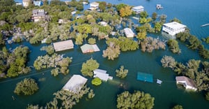
The European Space Agency – ESA has published an article highlighting the MIS GEO platform. GEO amalgamates highly accurate geotagged data from a range of sources to identify and track damage to property and infrastructure caused by catastrophic events such as natural disasters, allowing insurers to better serve their clients in their time of need
From 1970 to 2019, weather, climate and water hazards accounted for 50% of all disasters and 74% of all reported economic losses according to the World Meteorological Organization.
MIS understands the need for accurate, near real-time reactive data and is working on improving GEO for our clients daily.
Read more on ESA website:
https://business.esa.int/news/assessing-insurance-risk-and-damage-digital-age