
we can enable a much more nuanced assessment of their loss footprint and help speed up the process for claims payments, ease the extent of claims costs, and, most importantly, benefit the policyholder.
– MIS
The Situation
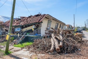
Hurricane Ida struck Louisiana on the 29th of August 2021, quickly becoming the second deadliest storm on record after Katrina. Widespread damage occurred due to the 150mph winds, and further damage was caused by heavy rain, flash flooding, and Tornadoes in certain parts of the state.
The event represented a familiar tale for most insurers accustomed to responding to largescale wind events; however, the addition of the extensive flooding and tornadoes created extra pressures on insurers to respond, not only to the internal demands of assessing their exposure but primarily to delivering a first-class claims response.
Our data-led response via our Global Events Observer (GEO) platform enables insurers to understand the extent of their exposure, even in the event of a loss where traditional stochastic modelling is unavailable. Our key differentiator is that our assessment is based on live, real-time data. Furthermore, a validated and overseen by our Intelligence team, consisting of data experts, ex-military intelligence officers and insurance professionals.
Exposure Management
Within the first 24 hours of the event occurring, we issued our exposure report, allowing exposure managers to validate and refine any assessment f the storm run by stochastic models and provide detailed insights into the extent of the flooding and tornadoes.
The benefit for exposure managers is that by consuming our data-led output, they can make more delicate assessments on the scope of the event, reducing their range of potential loss and allowing for a higher level of confidence in any numbers reported to the C-suite.
Where the flooding and tornadoes occurred, we were again able to provide detailed insights into the events where sophisticated models didn’t exist. We have also worked hard in establishing our own insights hub on GEO, meaning that where insurers can provide us with risk information before or during the event, we do the hard work for them, meaning that shapefiles don’t need to be downloaded and the process of exposure managers is enhanced.
Claims
There is no doubt that imagery plays a big part in the response, but that’s only one element of our product. Using multiple streams of data, both open source and licensed (wind speed, flood levels, local emergency reports, radar), we built a picture of ground truth that was verified by our intelligence team. For Hurricane Ida, our claims product was available within 48 hours and allowed insurers to:
- Establish ground truth where access was restricted
- Implement a data-led operational response to the event
- Triage claims pre-notification and, in some cases, make payments and claims decisions.
Output
Suppose insurers work with us before an event by sharing risk information and setting permissions for claims decisions. In that case, we can enable a much more nuanced assessment of their loss footprint and help speed up the process for claims payments, ease the extent of claims costs, and, most importantly, benefit the policyholder. Our data can also be extracted by insurers post-event and fed back into their pricing and underwriting processes.
Feel as though you could be better prepared to tackle #hurricaneseason?
Get in touch with Daniel Grimwood-Bird for more information.