
Last month, we collaborated with our technology partner, Maxar Technologies, on a blog to showcase our important partnership by exploring two case studies.
The blog was originally published by Maxar Technologies and can also be viewed here.
- By leveraging best in class imagery through Maxar’s cloud-based SECUREWATCH platform we have developed a unique offering for the (re)insurance industry, which enables our clients to:
- Understand and model risk better by understanding the situation on the ground with pinpoint accuracy;
- Identify trends and uncover patterns with global archive imagery, and answer time critical questions that traditional methods simply cannot;
- Improve the speed and accuracy of exposure management and claims services by using data, not models; and
- Use before and after imagery to assess damage, paying claims from space.
Natural catastrophes are profoundly destructive, leaving behind a trail of injury, death, loss of livestock, property damage and economic and insured losses. Meteorologists are already predicting that this year’s storm season will be unusually active, with some forecasts predicting 25% more hurricanes and storms than an average year.
Natural disasters, including storms, fire and earthquakes, cause some of the biggest losses to the (re)insurance industry year after year, which is why it has become so important to understand claims events in real-time with high cadence and high-resolution satellite imagery and analytics.
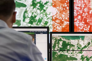
At MIS, we depend on the resolution, accuracy and timeliness of Maxar’s imagery to provide greater accuracy and responsiveness to its customers. In turn, our clients are able to rely on the imagery to make swift, accurate decisions on claims and get help to policyholders when they need it most.
Our global insurance partners expect to receive the highest resolution imagery and data commercially available, and we provide that through Maxar’s SecureWatch offering.
We also utilise satellite imagery from the whole electromagnetic spectrum, including synthetic aperture radar, which can see through clouds, and infrared, which can monitor the health of crops.
Case Study: April 2020 Tornadoes in the United States
In April 2020, as many as 60 tornadoes ripped through Louisiana, Texas and Mississippi, while severe storms also hit parts of Alabama, Georgia and the Carolinas.
By combining Maxar’s world-class satellite imagery and other sources of intelligence, we published an initial exposure report on the tornadoes within 24 hours, alerting customers and clients (including one of the largest (re)insurance markets in the world, Lloyd’s of London). Our analysis of the imagery provided intelligence into the scope of the damage and indicated where claims are likely to be most severe.
Additionally, the team quickly delivered complete remote assessments using accurate satellite imagery and on-the-ground data to help their clients deliver differentiating customer service, as well as providing operational efficiency, since on-the-ground loss adjusting was reduced.
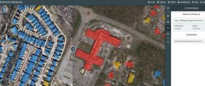
Image caption: In these comparative Maxar satellite images, polygons created from pre-tornado imagery are overlaid on post-tornado imagery and color-coded to indicate the level of damage to the buildings: red means destroyed, yellow means damaged and blue indicates no damage.
The social distancing and business restrictions that were in place in April 2020 because of Covid-19 significantly hampered the on-the-ground response following the disaster. Because our service leverages space-based data, claims and exposure management teams can respond promptly to customer requests without needing in-person evaluations of damaged property.
Case study: Australian Bushfires
Record-breaking temperatures and months of severe drought fuelled a series of massive bushfires across Australia at the end of 2019 and the beginning of 2020.
In the worst-hit state, New South Wales (NSW), fire was reported to have affected more than five million hectares, destroying more than 2,000 houses and forcing thousands to seek shelter elsewhere.
As the extreme weather event unfolded, we assisted exposure management and claims teams in assessing the impact of the fires on their insured locations, aiding in proactive and informed decision-making.
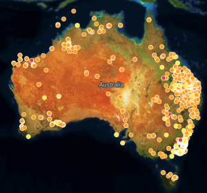
Image caption: The graphic shows locations of bushfires in Australia between the end of 2019 and beginning of 2020 as detected by Visible Infrared Imaging Radiometer data (VIIRS) from Maxar. Red dots indicate more fires are in the area, orange dots indicate a mid-number of fires and yellow dots indicate the fewest fires.
With the fires providing little respite and few smoke-free days, traditional satellite imagery posed a problem due to its inability to see through the thick smoke. However, Maxar’s WorldView-3 satellite hosts a shortwave infrared (SWIR) sensor that can see through smoke and identify active fires and burnt areas. We accessed this SWIR imagery through SecureWatch and, using imagery analyst expertise as well as machine learning, observed the bushfire’s destruction at a continental scale, reviewing over 500,000 square kilometres of imagery for damage.
This capability created an important service differentiator for the MIS team and it was critical in determining the outcome of an insurance claim, which had AUD $250 million at stake.
The future of paying claims
Accurate collection and timely dissemination of intelligence is vital at a time when uncertainty is rife and data sources are numerous and disparate.
Seasoned professionals can conduct global geospatial intelligence work to answer time-critical insurance requirements and help assess the economic impact of any event using best-in-class satellite imagery and the assistance of artificial intelligence and machine learning.
Rising catastrophic losses have necessitated a new approach from the (re)insurance market, and in recent years, we have seen and participated in the start of this transition, which has been an amazing journey.