
The client
We delivered intelligence to claims teams across the Lloyd’s market when their policyholders needed their insurer the most, utilising cutting edge technology to help them make decisions as a particularly intense wildfire season devastated the USA.
The problem
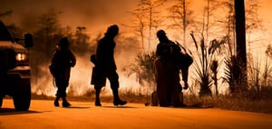
US wildfires are growing in severity every year, and the devastation can destroy entire communities and result in huge ecological impacts.
As fires rage and cordons remain in place, policyholders and insurers are left in the dark about the extent of damage and how to respond, having to rely on out of date adjusting processes and patchy information.
The Solution
MIS utilised our global network of drone pilots to obtain ultra high resolution, targeted imagery of the sites in question and deliver this visual information to our clients via our easy to use MIS Intel system. We also used cloud penetrating VIIRS (Visible Infrared Imaging Radiometer Suite) imagery to map infrared hotspots and track fires over time, delivering precise timelines to enable correct claims decisions to be made in real time.
Long before cordons were lifted and homeowners had even contacted their insurers, we had delivered accurate, trustworthy intelligence which allowed the claims to be paid without delay.
The Results
During the 2020 wildfire season we enabled several insurers to pay total loss claims within days of the event, whilst the fires were still burning. Our clients were able to save $000’s in loss adjusting fees as well as deliver a world beating policyholder service which was of great comfort and support to their customers.