


CONSULTANCY

OUR CONSULTING SERVICES

We extend comprehensive support to clients through our dedicated client solutions team. We utilise available data to conduct investigations and address property-related inquiries, offering assistance from initial stages of investigation to crucial litigation processes.

We offer rapid and comprehensive intelligence insights to clients with property portfolios, allowing them to grasp the significance of events that impact their interests. Clients gain priority access to our in-house task matrix, ensuring swift delivery of complex deliverables to meet their needs efficiently.
We collaborate with data providers who offer an extensive collection of imagery obtained from sources such as satellites, aerial platforms, drones, and sensors. We curate and deliver this data to clients according to their specific requirements and preferences.
We empower clients through detailed training by sharing our knowledge and best practices in applying intelligence solutions. We offer training in three functions: Intelligence, Imagery-Based Investigations, and Imagery Analysis.

We provide geospatial solutions that help clients thoroughly understand and solve their specific challenges. We offer imagery-based investigations and guidance on how to integrate intelligence effectively for more efficient internal operations.


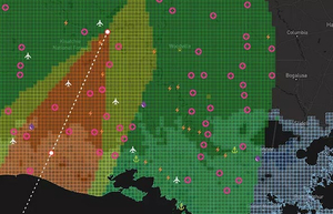
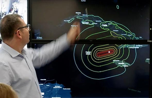
Case study: Quantifying business interruption following a catastrophic hurricane

MEET THE TEAM


Intelligence Analyst

Senior Imagery Analyst

Senior Imagery Analyst